
A client calls to have their asphalt driveway redone. They live 45 minutes away. You drive out, take your measurements, drive back, and put the quote together that evening. And sometimes, they never call back.
For many paving, landscaping and excavation contractors, this happens every single week. Remote measurement lets you skip the site visit for most of your quotes. Here is how it works, what you can measure, and most importantly, when a site visit is still necessary.
What is remote measurement?
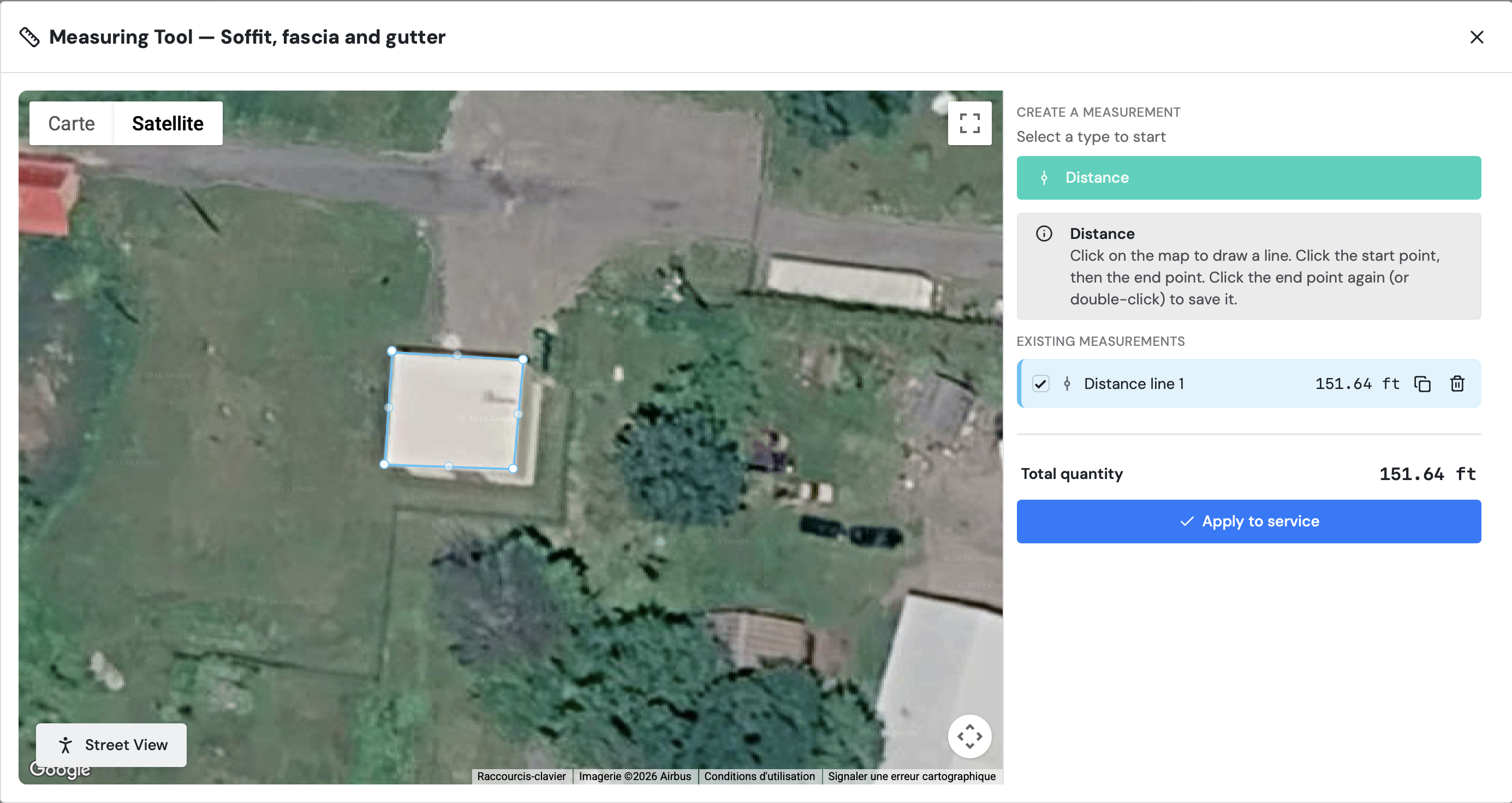
Remote measurement means taking a property's dimensions from a satellite view, right on your computer or phone. You enter the client's address, trace the outline of the area, and the tool calculates the length or the surface area.
Instead of showing up at the client's door with your measuring tape, you prepare your estimate from the office, from your truck, or between two jobs.
What kind of work can you measure remotely?
Satellite measurement works well for anything that is visible from above and relatively flat. For example:
Paving and asphalt: driveways, parking lots, walkways
Pavers and edging: surface area and edging length
Lawn and sod: area to sod or maintain
Landscaping: flower beds, mulch areas, retaining walls
Excavation and drainage: area to dig, length of a drain
Fencing: length of the perimeter to fence
Irregular shapes are not a problem. Simply add more points as you follow the outline, and the area is calculated automatically.
How to measure a property remotely, step by step
Whether you use a free tool like Google Earth or quoting software, the method is the same.
Find the property. Enter the client's exact address and zoom in until you can clearly see the edges of the area.
Trace the outline. Click point by point around the surface. For an irregular shape, add more points along the curves.
Write down the area or length. Keep each zone separate (driveway, walkway, flower bed) so you can itemize your quote.
Add your margin. Include a waste percentage for cuts, adjustments and surprises, just like you already do on site.
Apply your prices. Multiply the area by your price per square foot or square metre, then add labour, materials and taxes.
To build a complete, professional quote from these measurements, read our guide to writing a construction quote.
How much remote measuring can save you
Let's run the numbers with a realistic example. You do 5 estimate visits a week, an average of 20 miles from your shop, so 40 miles round trip. That is 200 miles a week.
The IRS raised its business standard mileage rate to 76 cents per mile as of July 1, 2026. It is a good benchmark for what it really costs to put miles on a truck. At that rate, those 200 miles come to about $152 a week. Over a 30-week season, that is more than $4,500, before you count your time.
And your time adds up fast: at an hour and a half per visit including the drive, that is 7.5 hours a week behind the wheel. Almost a full workday you could spend running jobs or bidding on more work.
Even if you only replace half of your site visits, the savings are real.
Get your price in before the competition
Speed matters as much as price. A study published in the Harvard Business Review found that companies that responded to an online inquiry within an hour were nearly 7 times more likely to have a meaningful conversation with the prospect than those that waited longer.
When a homeowner gets three bids, the one that shows up the same day has the edge. With remote measuring, you can send a price while they are still ready to decide, instead of offering to swing by next week.
The limits of remote measurement (and when a site visit is still needed)
Remote measurement replaces the visit for preparing the quote. It does not always replace the visit before the work starts. Here are the situations where it is better to go see the property in person:
Trees or buildings hiding the area: if the surface is not visible in the image, the measurement will be approximate.
Steep slopes: the satellite view shows a flat surface. A sloped property has a larger real surface area.
Soil depth and type: for excavation, a satellite image tells you nothing about rock, clay or the water table.
Condition of the existing surface: an old driveway to remove, cracks or poor drainage are easier to assess in person.
Equipment access: the width of a passage or the presence of power lines should be checked on site.
The best approach: quote remotely to move fast, then confirm the measurements on site once the contract is signed, when you plan the work. You only travel for clients who said yes.
What you actually gain
Less driving, more quotes
Run the numbers for your business. If each estimate visit takes you 1.5 hours including the drive, and you send 5 quotes a week, that is more than 7 hours a week spent in the truck. Those hours could go toward managing your jobs or bidding on more projects.
Respond before your competitors
A client who asks for three quotes often chooses from the first ones they receive. With remote measurement, you can send a price the same day they call, while the client is still ready to decide.
Save your time for serious clients
Some requests never turn into a contract. When a quote takes minutes to prepare, a client who is just shopping around costs you far less than a half-day trip.
Lower vehicle costs
Fewer kilometres means less fuel, less wear on the truck and fewer emissions.
A tip to make your estimates stand out
You already have a picture of the house in front of you, so put it to work. Some contractors add an edited image of the property to their estimate to show the finished result: black soffits, a garage door in a new color, a new paver driveway. The homeowner no longer sees just a price, they see their house after the job. It often changes the conversation.
Measure and quote in the same tool with PlanOps
Measuring remotely with Google Earth works, but you then have to copy everything into a quote. In PlanOps, measuring and quoting happen in the same place:
You enter the client's address and the satellite view opens right in the app.
You trace your zones (lengths, areas, irregular shapes).
The price is calculated automatically from your price list, taxes included.
Client details are filled in from your CRM.
You send the quote in one click and see when the client opens it.
The client signs electronically, and the signed contract is filed automatically in their record.
During onboarding, our team sets up your price lists, logo and quote templates with you. You start with a tool that is already adapted to the way you work.
Frequently asked questions
Is satellite measurement accurate enough for a quote?
Yes, when the image is recent and the area is clearly visible. For a quote, the accuracy is comparable to a quick on-site measurement. Include your usual margin and confirm the measurements before the work starts.
Is Google Maps enough to measure a property?
Google Maps and Google Earth let you measure distances and areas for free. The downside is that you then have to enter the numbers into your quote by hand. Quoting software with built-in measurement skips that step and avoids copying errors.
Can you measure a sloped property remotely?
You can measure the surface as seen from above, but the real area of a sloped property is larger. For a steep slope, adjust your calculation or confirm on site.
Does the client need to be there?
No. All you need is their address. The client then receives the quote by email and can sign it online.
Which contractors benefit most from remote measurement?
Mainly contractors who work outdoors: paving, asphalt, pavers, landscaping, lawn care, excavation, drainage and fencing.